Accepted to IEEE Transactions on Geoscience and Remote Sensing (TGRS), 2026
High-quality annotated datasets are critical for semantic segmentation, particularly in aerial imagery, where the number of manually annotated frames is limited and precise labeling is often missing. To address this, we introduce UAVid++, a semantically refined and expanded version of the UAVid dataset for aerial semantic segmentation. The proposed dataset provides higher-quality annotations through manual corrections addressing labeling errors across the entire original UAVid dataset. In addition, we expand the taxonomy with three finely annotated semantic classes, Water, Sky, and Roof, selected to enrich the semantic space and separate visually distinct objects previously grouped together under the same label. We evaluated state-of-the-art aerial segmentation methods on UAVid, UAVid+ (with corrections, without expanded taxonomy), and the full UAVid++ dataset. Corrected annotations improved both training and evaluation performance by up to 7.4% mIoU, and adding the three classes further increased performance by up to 4.1%, demonstrating the combined impact of refined labels and the expanded semantic taxonomy. UAVid++ enables more discriminative evaluation of state-of-the-art methods and improves their relative ranking. We adapt frozen DINO-pretrained ViT backbones using trainable task-specific heads for UAV semantic segmentation. This strategy achieves strong segmentation performance and robust generalization while quantifying the gains from improved labels relative to pretrained backbone capacity. Relative to the best-performing state-of-the-art method, our configurations achieve a 2.7% mIoU improvement on UAVid++, up to 12.4% mIoU gains on out-of-distribution UAV datasets, and a 38.85% mIoU gain on a cross-domain dataset.
Labeling errors and coarse contours are manually corrected across the entire UAVid dataset, and the taxonomy is expanded from 8 to 11 classes to improve semantic separability and reduce unlabeled regions.
Five state-of-the-art methods re-trained and re-evaluated on every variant, where corrections alone add up to +7.4% mIoU and the expanded taxonomy a further +4.1%. They cluster near 69% mIoU on the original UAVid, but UAVid++ produces a wider distribution of scores and improves their relative ranking.
Lightweight trainable heads on a frozen DINO-pretrained ViT backbone reach 82.04% mIoU on UAVid++, +2.7% over the best state-of-the-art method. They also generalize well, gaining up to +12.4% on unseen UAV datasets and +38.85% on cross-domain satellite imagery.
Better labels are worth +9.2% mIoU, while scaling the frozen backbone from 840M to 6.7B parameters yields only +0.6%. For aerial imagery, where annotated data is limited, label quality matters far more than backbone size.
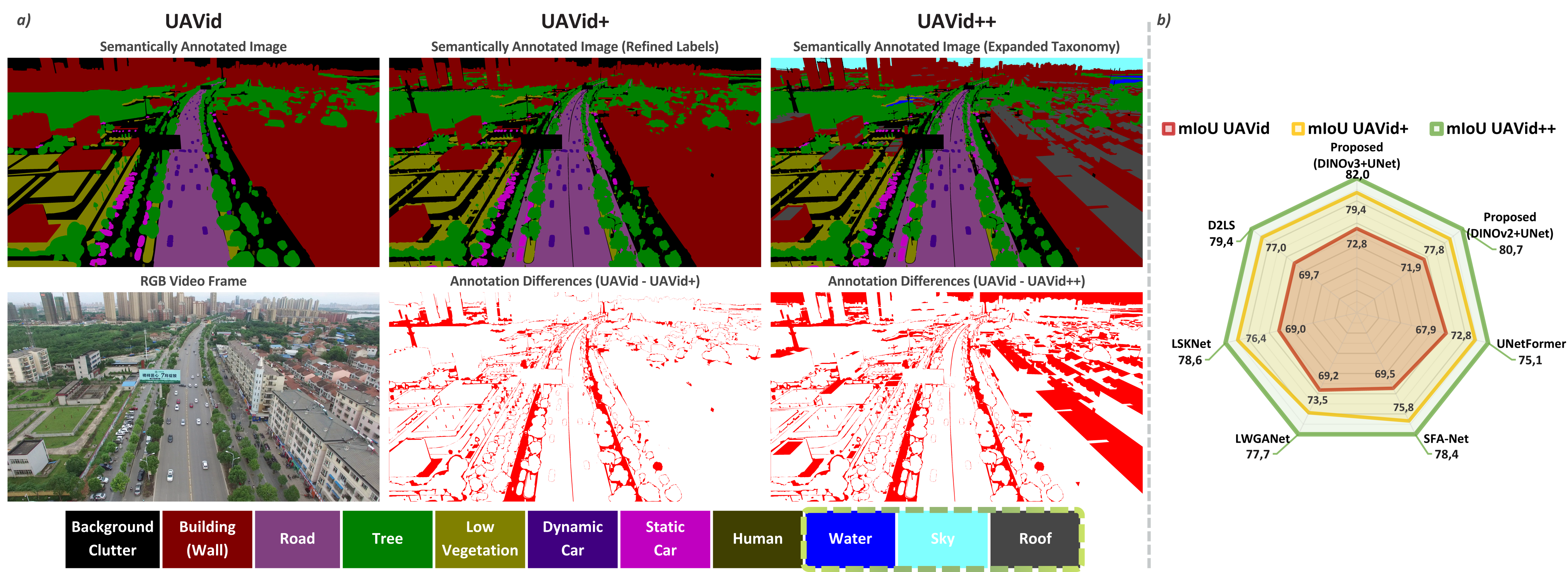
Two new variants derived from the same 420 annotated frames of UAVid, so corrections and the expanded taxonomy can be measured separately.
The original oblique-view aerial dataset with 8 semantic classes.
Corrected annotations only, across the same 8 categories as UAVid.
Corrected annotations and new classes. Water, Sky and Roof are added to the refined labels, bringing the taxonomy to 11 categories.
All visible water surfaces, regardless of reflectance. Objects in the water keep their own class down to the waterline, and wet ground without pooling is not Water.
All visible sky, including clouds and haze. Backlit objects keep their own label up to their visible outline.
All upper surfaces of a building, plus roof-mounted equipment such as air-conditioning units and solar panels.
The DINO-pretrained ViT backbone stays frozen and only a lightweight head is trained on top.
A single layer mapping frozen features directly to the semantic label space. With ViT-H+ it adds only ~15.3K trainable parameters.
Two sequential Conv-BatchNorm-ReLU blocks, the second halving channels. ~22M parameters when coupled with ViT-H+.
Three downsampling stages, a C/16 bottleneck, three upsampling stages and skip connections. ~26M parameters with ViT-H+.
In-distribution results across the three variants. Corrected labels and the expanded taxonomy lift every method, and change how they rank against each other.
Tables II & III - In-distribution results on UAVid, UAVid+ and UAVid++ (mIoU %). Cross-evaluation between UAVid and UAVid+ exposes annotation issues in the original training and test splits; UAVid++ adds further gains through its expanded taxonomy. Green values indicate gains over UAVid.
| Train | Test | State of the art | Ours - frozen DINO ViT + trainable head | ||||||||
|---|---|---|---|---|---|---|---|---|---|---|---|
| UNetFormer | LWGANet | SFA-Net | LSKNet | D2LS | ViT-g UNet | ViT-H+ Linear | ViT-H+ Conv | ViT-H+ UNet | ViT-7B UNet |
||
| UAVid | UAVid | 67.87 | 69.18 | 69.52 | 69.03 | 69.68 | 71.91 | 63.17 | 72.03 | 72.23 | 72.82 |
| UAVid | UAVid+ | 70.38 2.5 | 72.33 3.1 | 72.64 3.1 | 72.65 3.6 | 72.72 3.0 | 75.02 3.1 | 65.95 2.8 | 75.34 3.3 | 75.74 3.5 | 76.26 3.4 |
| UAVid+ | UAVid | 68.38 | 68.01 | 70.16 | 70.63 | 70.94 | 72.70 | 63.19 | 72.56 | 73.30 | 73.45 |
| UAVid+ | UAVid+ | 72.83 5.0 | 73.52 4.3 | 75.85 6.3 | 76.44 7.4 | 76.96 7.3 | 77.83 5.9 | 66.29 3.1 | 77.96 5.9 | 78.67 6.4 | 79.41 6.6 |
| UAVid++ | UAVid++ | 75.07 7.2 | 77.66 8.5 | 78.43 8.9 | 78.61 9.6 | 79.35 9.7 | 80.68 8.8 | 70.13 6.9 | 80.86 8.8 | 81.42 9.2 | 82.04 9.2 |
LSKNet ranks fourth of five on the original UAVid but second on both corrected variants, so annotation quality changes how these methods rank against each other. On UAVid++ the best configuration beats the strongest state-of-the-art method by 2.7% mIoU (82.04 vs. 79.35). Growing the frozen backbone from ViT-H+ (840M) to ViT-7B (6.7B) is worth only ~0.6%, against 9.2% from improving the data alone.
Trained only on UAVid++ and evaluated without any retraining on unseen UAV datasets and on high-altitude aerial and satellite imagery.
Tables VII & VIII - Generalization without retraining (mIoU %). UDD and VDD are unseen UAV datasets; OpenEarthMap is high-altitude aerial and satellite imagery under a severe domain shift. Green values indicate gains over D2LS (SOTA).
| Test set | Method | mIoU |
|---|---|---|
| UDD | D2LS | 55.46 |
| ViT-H+ Linear | 64.58 9.1 | |
| ViT-H+ UNet | 67.89 12.4 | |
| VDD | D2LS | 60.14 |
| ViT-H+ Linear | 65.98 5.8 | |
| ViT-H+ UNet | 69.00 8.9 | |
| OpenEarthMap | D2LS | 24.1 |
| ViT-H+ UNet | 62.95 38.85 |
The dataset and the implementation are publicly released for reproducibility and further research.
UAVid+ and UAVid++ frames: corrected and expanded semantic annotations, with the full documentation.
The complete implementation, including the training and inference protocol, model configurations and evaluation scripts.
Checkpoints for the model configurations reported in the paper.
UAVid++ is derived from the UAVid dataset and, in accordance with the ShareAlike terms of UAVid's license, is released under the same Creative Commons Attribution-NonCommercial-ShareAlike 4.0 International License (CC BY-NC-SA 4.0). This website was adapted from the Nerfies project page.
@article{chiciudean2026uavidplusplus,
author={Chiciudean, Vivian and Nedevschi, Sergiu and Oniga, Florin},
journal={IEEE Transactions on Geoscience and Remote Sensing},
title={UAVid++: Higher-Quality Labels and Expanded Semantic Taxonomy for Aerial Semantic Segmentation},
year={2026},
volume={},
number={},
pages={1-1},
doi={10.1109/TGRS.2026.3715191}}
This work was supported by the Romanian Hub for Artificial Intelligence – HRIA project, Smart Growth, Digitization and Financial Instruments Program, MySMIS no. 351416, Ministry of Investments and European Projects, Romanian Government.